The Effect of Changes in Land Use and Rainfall on Flood Discharge in Batang Watershed in 2012 and 2022
DOI:
https://doi.org/10.37934/ard.128.1.3546Keywords:
Batang watershed, land use, floodAbstract
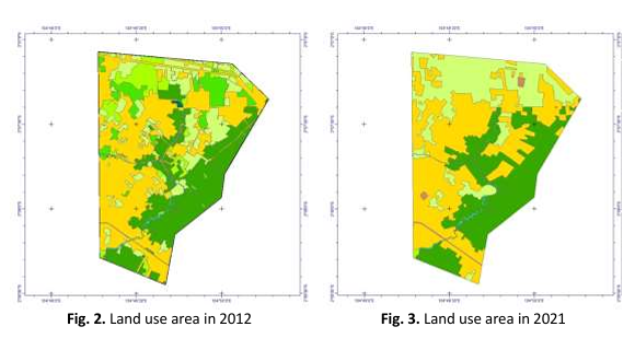
The Batang Watershed is located in Kalidoni District and is one of the watersheds that frequently experiences flooding in Palembang. Kalidoni District had a population of 126,207 people in 2021, with an area of 27.92 km2. It is a flood-prone area with a high classification. This research aims to analyse the flood discharge of the Batang watershed in Palembang City using the Rational method based on changes in land use and the amount of rainfall that occurred in 2012 and 2022. The results of the analysis of flood discharge in the Batang watershed have increased from 2012 to 2021. Factors that lead to increased discharge include high rainfall, with a value of 144.33 mm in 2012 and 168.68 mm in 2022. Changes in land use in the Batang watershed in the form of residential buildings and roads have significantly increased. However, land use in Paddy fields and fields also experienced a significant increase, so many catchment areas are still available in the Batang watershed. The results of the flood discharge analysis with a return period of 10 years showed an increase in flood discharge of 33.01%; the flood discharge in 2012 was 22.23 m3/s, and in 2022 it was 29.68 m3/s.
Downloads
Downloads
Published
How to Cite
Issue
Section